
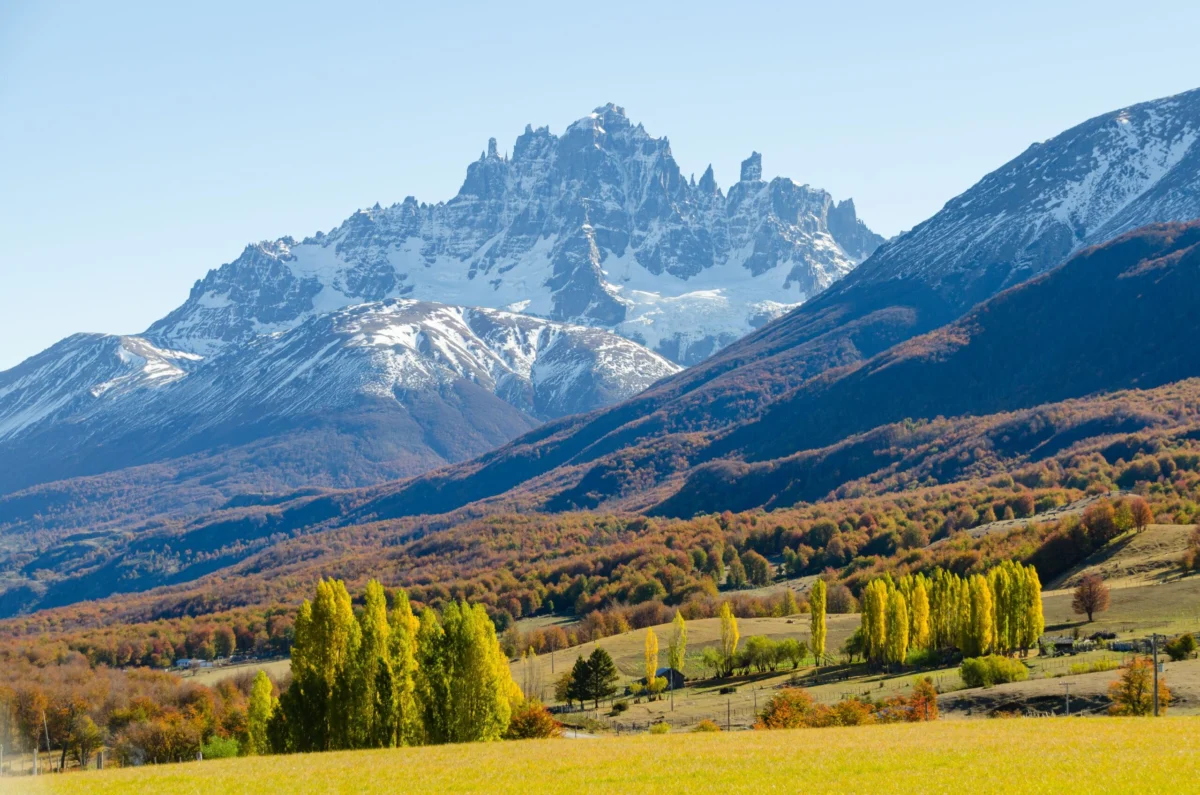
One of the world’s most celebrated road trips owes its existence not to the whims of tourism, but to the cold, calculated paranoia of a dictator. In the 1970s, Augusto Pinochet, having solidified his grip on Chile through a brutal military coup, looked toward the nation’s southern frontier with intense suspicion. He feared that the isolated Aysén Region—a jagged, impenetrable landscape where rainforests swallow the light and volcanoes pierce the clouds—might eventually drift into the geopolitical orbit of neighboring Argentina.
To prevent this, Pinochet ordered the construction of an audacious highway running latitudinally through Northern Patagonia. The result, the Carretera Austral (Southern Highway), was forged by military might, dynamite, and thousands of hours of backbreaking manual labor. Fifty years later, this 770-mile ribbon of gravel and grit stands as a testament to both human endurance and the unintended consequences of authoritarian ambition.

Main Facts: A Highway Forged in Isolation
The Carretera Austral begins at an inlet of the Pacific near the port city of Puerto Montt and terminates in the remote frontier outpost of Villa O’Higgins. Traversing the road requires navigating four car ferries and contending with weather systems that can change in a matter of minutes. For decades, this route remained a logistical nightmare, effectively cutting off communities like Villa Cerro Castillo from the rest of the country. Before the road, residents in Aysén relied on horses, boats, and rudimentary airstrips to access essential goods and services. Today, the highway serves as the sole terrestrial lifeline for these communities, evolving from a strategic military barrier into a pilgrimage site for global adventurers.
Chronology: From Dictatorship to Destination
The evolution of the Carretera Austral can be mapped across five distinct eras:

- 1976: Construction begins under the Pinochet regime, driven by territorial anxiety and a desire to integrate the Aysén Region into the central Chilean state.
- The 1980s–1990s: The road begins to physically connect scattered, isolated settlements. The "pioneer" era defines the region as local ranchers move their homes closer to the newly cut path.
- The Early 2000s: The "discovery" phase begins. Backpackers, dirt-bag cyclists, and independent travelers begin to utilize the route, spreading word of the untouched wilderness, the Marble Caves, and the vast glaciers.
- 2010s–2020: The rise of conservation. The entry of philanthropic organizations, most notably Tompkins Conservation, shifts the narrative from mere extraction and survival to large-scale ecological restoration.
- 2024–Present: The transition to "rustic-chic" luxury. Boutique lodges like Alto Castillo and the expansion of the Mallin Colorado estancia mark the arrival of high-end tourism, signaling a pivot toward sustainable, nature-focused hospitality.
Supporting Data: A Demographic and Economic Shift
The impact of the Carretera Austral on the Aysén Region is quantifiable and profound. When construction first began, the region held fewer than 50,000 residents. Today, that number has more than doubled to over 100,000, bolstered by thousands of seasonal workers and a burgeoning real estate market for second homes.
In towns like Puerto Río Tranquilo, the transformation is total. Two decades ago, the local economy was dominated by traditional ranching, and a resident might go 15 days without seeing a visitor. Today, the economy is almost entirely dependent on tourism. Boat and kayak departures for the famous Marble Caves occur every 15 minutes during peak season. However, this growth has not been without cost. The increased traffic, while providing essential revenue, has put immense pressure on local infrastructure and the very ecosystems that draw visitors in the first place.

The Ecological Paradox: Rewilding vs. Recession
The Carretera Austral cuts through some of the most fragile environments on Earth. As travelers venture deeper into the Aysén wilderness, they are confronted with the dual reality of ecological recovery and environmental decay.
In the Exploradores Valley, the landscape is a study in contrasts. Private reserves like Exploradores Park, managed by long-time residents Francisco Croxatto and Tamara Ullrich, have seen the successful return of moss-covered forests to a more "feral" state. Yet, the glaciers that define the region—most notably the Exploradores Glacier—are in a state of rapid retreat. The government’s decision to suspend ice-hike services in 2026, citing the instability of the melting ice, serves as a sobering reminder of the global climate crisis.

Meanwhile, the Chacabuco Valley offers a glimpse of what intentional intervention can achieve. Through the efforts of Rewilding Chile and Tompkins Conservation, 221 rheas have been reintroduced to the plains. The removal of thousands of miles of fencing has allowed guanacos to return, which in turn has supported a population of roughly 30 pumas. This "trophic cascade" is a cornerstone of the region’s new identity, proving that tourism can fund the restoration of lost biodiversity.
Official Responses and Local Perspectives
The locals who live along the highway hold a complex, often conflicted view of their "backbone of connection." Many, like Francesco Rossi, General Manager of Mallin Colorado, acknowledge that the road’s lack of pavement is part of its charm. "If it was fully paved with lights and fences, it wouldn’t be the same," he notes. The rugged, unpaved nature of the highway serves as a natural filter, discouraging mass-market tourism while preserving the "Patagonian feel."

Others, like Cristian Vidal of Senderos Patagonia, emphasize the need for a middle path. Vidal, who works to preserve traditional gaucho culture, is spearheading efforts to create a 260,000-acre Multiple-Use Conservation Area in the Torres del Avellano region. His vision is one where heritage and conservation coexist: gauchos continue their ancestral practice of summer grazing while acting as stewards of the forests and mountains. "It’s about knowing where you come from, but also where you want to go," Vidal explains.
Implications: The Future of the Frontier
As the Carretera Austral enters its second half-century, its future remains a point of contention. The Chilean government faces the challenge of maintaining a road that is technically a "car killer" during the rainy seasons while balancing the demands of a growing tourism industry.

The primary implication of this development is the shift in power. For decades, the region was governed by the state and the ranchers. Now, it is increasingly influenced by conservationists, international NGOs, and high-end travelers. This transition promises economic prosperity for locals like those at Mallin Colorado or the new boutique operators, but it necessitates a rigid commitment to environmental ethics.
If the Carretera Austral is to remain a symbol of discovery rather than a conduit for degradation, the focus must remain on sustainability. The "luxury" now sought by visitors is not one of gold-plated faucets, but of the ability to witness the pampas cat in the wild, to hike pristine trails, and to experience the raw, unscripted beauty of the Patagonian wilderness.

The road is no longer just a path built to prevent an invasion; it is a laboratory for how we interact with the last wild corners of our planet. Whether the Carretera Austral continues to serve as a gateway to wonder depends on the ability of the Chilean state, local communities, and the international tourism sector to honor the fragility of the landscape that the dictator’s road first opened to the world. As the autumn sun glows over the Andes, turning the lenga forests into a palette of amber and red, the message remains clear: the road has brought the world to Patagonia, but the soul of the region remains rooted in the people who choose to protect it.
